Altheim test case
| Fact box: Altheim | |
|---|---|
| Country | Germany |
| River | Isar |
| Operator | UNIPER |
| Capacity | 17.8 MW |
| Head | 8.2 m |
| Inter-annual discharge | 163 m3/s |
| Turbine(s) | 5 Kaplan turbines |
| Detailed report | Click for pdf |
Contents
Introduction
The river Isar, located in the south of Germany, is an Alpine river. It flows from its source in Austria at 1600 m above sea level through the Alps, pre-alpine moorlands and through the city of Munich before entering the Danube river near Deggendorf at 300 m above sea level. With a length of 260 km it is the fourth largest river in Bavaria and the second most important tributary of the Danube in Germany.
The catchment area of the Isar covers 8960 km2 in the Alps and the Karwendel mountains. The Isar is generally divided into three sections: the Upper Isar, the Middle Isar and the Lower Isar. The Test Case hydropower plant Altheim is located in the Lower Isar, at km 67.2, near the town Altheim. Downstream of the Test Case, 7 additional hydropower plants are located along the Isar. The section of the Isar that relates to the Test Case Altheim has a catchment area of 88.2 km2 and is about 73 km long. It has an intern-annual discharge of 163 m3/s. It is classified as a waterbody with poor ecological status.
About the hydropower plant
The hydropower plant at Altheim, commissioned in 1951, is a block-type hydropower plant and part of a chain of power plants in the Isar. It has an installed capacity of 17.8 MW and a mean annual output of 91.4 GWh. The plant has a gated weir with 4 bays located on the right of the power house and a head storage volume of 1,980,000 m3.
The normal operating level is at 384.00 m above sea level, in swelling operation it can be lowered by 1.00 m. On average, there are 2 peaks per day, where the flow changes roughly between 50 m3/s and 170 m3/s with ramps of about 100 m3/s per hour or a change of water level between +45 cm/h to - 30 cm/h.
Layout
The area around the power plant is dominated by commercial and living areas on the left side and a popular local recreation area with lakes for swimming on the right side, as well as a sewage treatment plant in Altheim.
The Operator: Uniper SE
Uniper Hydro Germany operates 109 hydroelectric power plants, containing run of river plants, storage and pumped storage. Alongside the rivers Lech, Isar, Danube and Main more than 1300 kilometres are used for the production of clean electricity. In close cooperation with regional stakeholders (politicians, authorities, NGOs) Uniper takes over responsibility to protect civil areas from floods, but also to protect the environment. Read more.
Pressures on the water body's ecosystem
The main pressures on the water body are nutrients, river specific pollutants, agricultural production and hydromorphological changes. These are on the one hand related to agriculture on the other hand the hydromorphology is impacted by the sequence of hydropower plants and their related ponds. Moreover, the chemical pressure (especially mercury) cannot be neglected.
Test case topics
Fish population
The relevant water body is located in the barbel region (epipotamal) and is therefore dominated by potamodromous species. During electro fishing in autumn 2007, 43 fish species could be identified, containing 35 indigenious species, 27 red listed species and 9 FFH species, which were mainly rheophile fish. Out of those, six were endemic species: Hucho hucho, Rutilus pigus, Gobio albipinnatus, Gymnocephalus schraetser, Zingel zingel and Zingel streber.
Upstream migration
The dimensioning criteria for the upstream migration facility, which was built in 2015, were the fish species Barbus barbus and Hucho hucho. The fish pass consists of a rough channel for the downstream connection at the entry of the fish pass. It is located on the right-hand side 300 m downstream of the power plant. An existing ditch has been used to facilitate the fish passage over 4.5 km and for providing new hydromorphological structures and habitats in the fish pass. Upstream, a vertical slot connects the nature-like fish pass to the river. This migration facility is always supplied with a minimum flow of 450 l/s which can be extended to up to 800 l/s.
E-flow
HPP Altheim is one HPP in a chain of hydropower plants. Usually a minimum flow of 40 m3/s is operated, a full stop of machines is a rare exception. For own purposes, one machine for station supply must always be operated with a minimum of 11.7 m3/s. Although the connected small stream Längenmühlbach has an agreed minimum e-flow of 3.2 m3/s all year, it is not within the scope of the Altheim Test Case within FIThydro.
Research objectives and tasks
Within the project, the fish pass at the plant shall be evaluated regarding the effectiveness of its existing hydromorphological structures. Both, the variation of the original structures to the current status as well as the usage of the existing habitats by fish shall be evaluated. Based on the results a concept for improved hydromorphological measures shall be developed under the consideration of acceptance by fish and expenses for maintenance. Moreover, the experiences with the maintenance of the nature-like fish passes shall be evaluated. This will be relevant for further decisions on the implementation of upstream migration measures.
Research tasks
The research tasks and field studies conducted at the Altheim HPP are:
- Mapping the availability of habitat structures and analysing their added value for migrating fish
- Evaluating the maintenance costs of a nature-like fish pass
Results
Over a total length of 1.5 km of the natural fish pass one habitat structure every 100 m has been implemented. The structures mainly consist of dead wood and spawning gravel and were constructed as spawning habitats, juvenile habitats or shelter but also to generally increase the variability in flow conditions. 5 structures are being observed with underwater photography in comparison to similar locations within in the fish pass without structural improvements to compare the effects and benefits. The first impressions indicate that the new habitat structures show a much higher density of the relevant fish species.
Gallery
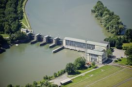
Aerial view of Altheim dam, power plant, and reservoir.
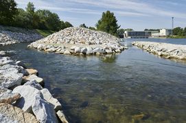
Entrance to the nature-like fishway in Altheim.
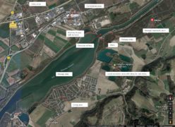
Layout of the Altheim powerplant and the surrounding area,
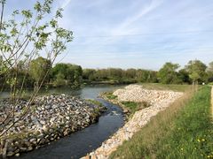
View of the Altheim nature-like fishway from downstream.
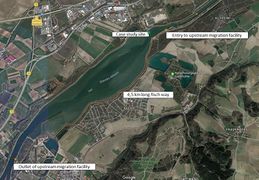
Layout of the Altheim fish migration system.


