Difference between revisions of "File:Lidar setup.png"
Jump to navigation
Jump to search
Kordula NTNU (talk | contribs) |
Kordula NTNU (talk | contribs) |
||
| Line 1: | Line 1: | ||
{{Information | {{Information | ||
|author= Mallet 2010 | |author= Mallet 2010 | ||
| − | |source= Mallet C., 2010; LIDAR aéroportéstopographiques & bathymétriques | + | |source= Mallet C., 2010; LIDAR aéroportéstopographiques & bathymétriques; ; [https://www.umr-cnrm.fr/ecole_lidar/IMG/pdf/Mallet-Topo_Bathy_Veget.pdf] |
|description= Basic set up of a Lidar measurement | |description= Basic set up of a Lidar measurement | ||
}} | }} | ||
Latest revision as of 08:31, 30 September 2020
| Description |
Basic set up of a Lidar measurement |
| Author |
Mallet 2010 |
| Source |
Mallet C., 2010; LIDAR aéroportéstopographiques & bathymétriques; ; [1] |
File history
Click on a date/time to view the file as it appeared at that time.
| Date/Time | Thumbnail | Dimensions | User | Comment | |
|---|---|---|---|---|---|
| current | 10:08, 19 June 2019 | 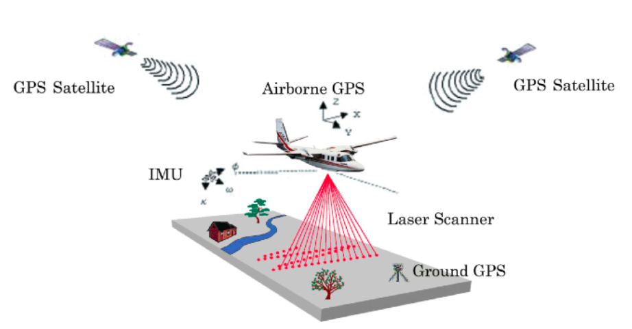 | 922 × 481 (158 KB) | Bendikhansen (talk | contribs) |
- You cannot overwrite this file.
File usage
The following page uses this file: