Difference between revisions of "Sediment simulation in intakes with Multiblock option (SSIIM)"
Bendikhansen (talk | contribs) |
Bendikhansen (talk | contribs) m (Text replacement - "[::Category" to "[:Category") |
||
| Line 9: | Line 9: | ||
Type: [[:Category:Tools|Tool]] | Type: [[:Category:Tools|Tool]] | ||
| − | Suitable for the following [[ | + | Suitable for the following [[:Category:Measures|measures]]: |
=Introduction= | =Introduction= | ||
Revision as of 13:20, 29 October 2019
Contents
Quick summary


Developed by: NTNU
Date:
Type: Tool
Suitable for the following measures:
Introduction
SSIIM is a numerical model to simulate the hydraulics and sediment transport including bed changes as well as various other parameters related to water quality in fluvial environment. It solves the Reynolds-averaged Navier-Stokes equations in all three directions and calculates the turbulent kinetic energy and dissipation through the standard k- model. The calculated bed changes are directly coupled to the time steps in the hydraulic computations. SSIIM can use both, an unstructured and a structured grid to discretize the domain of interest.
Application
After downloading the SSIIM executable from the webpage mentioned below, the text files "control" and "koordina" have to be established. The control file lists all the control parameter which SSIIM is supposed to execute. There are various parameters depending on the results the user wants to achieve. The koordina file is used to describe the geometry of interest.
Figure 1 shows the flow chart in which way SSIIM is working.
The application of the user does not require any coding, however, the user has to specify certain parameters and the geometry as text in the above mentioned files. These files are generated with any text editor and linked to the main executable. A detailed description can be taken from the manual (Olsen, 2018). The application varies from the most basic simulation of a steady state hydraulic computation to the most complex one, when combining unsteady flow with multiple sediment sizes and wetting and drying of parts of the geometry.
INPUT: To start a most basic version of a time dependent sediment transport model of a river reach you have to have the geometry in terms of a point cloud file, the discharge Qin=out, the waterlevel height at the downstream end of the reach and the prevailing sediment grain size distribution at the river bed.
OUTPUT: All the available output parameters can be displayed in the graphical user interface and copied into the clipboard (Figure 2). In addition, it is possible to use a separate post processing tool, like freeware Paraview (https://en.wikipedia.org/wiki/ParaView) or commercialized Tecplot (https://en.wikipedia.org/wiki/Tecplot).
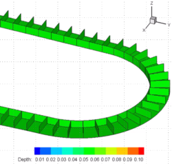
Figure 3a, examples of SSIIM simulations
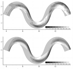
Figure 3b, examples of SSIIM simulations
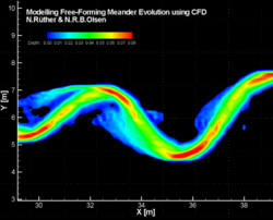
Figure 3c, examples of SSIIM simulations


Other information
The numerical model can be download free of charge at the webpage listed below. There is a large user group and information is available at many places.
Relevant literature
- Olsen, N.R.B. (2018), SSIIM user manual (http://folk.ntnu.no/nilsol/ssiim/manual5.pdf)