Difference between revisions of "Guma and Vadocondes test cases"
Bendikhansen (talk | contribs) |
Bendikhansen (talk | contribs) |
||
| (35 intermediate revisions by 2 users not shown) | |||
| Line 4: | Line 4: | ||
=Introduction= | =Introduction= | ||
| − | The Test Cases of Guma and Vadocondes are situated on the Duero river, which is located in the northwestern part of Spain. The source of the Duero river is in the Castilla y León region, which it crosses from East to West to then enter Portugal where it finishes its way into the Atlantic ocean. The total length of the river is about 900 km and the catchment area is 98,400 | + | The Test Cases of Guma and Vadocondes are situated on the Duero river, which is located in the northwestern part of Spain. The source of the Duero river is in the Castilla y León region, which it crosses from East to West to then enter Portugal where it finishes its way into the Atlantic ocean. The total length of the river is about 900 km and the catchment area is 98,400 km<sup>2</sup>. The presence of hydropower plants (HPPs) in the Duero river is quite common, with 140 small hydropower plants (below 5 MW) and 23 large HPP situated on the Duero river. |
The hydrology of the Duero river on this zone is characterized by low flows in summer (regulated flow for irrigation mostly derived through channels) and medium-high flows during winter and early spring, associated with rainy season and snow episodes. | The hydrology of the Duero river on this zone is characterized by low flows in summer (regulated flow for irrigation mostly derived through channels) and medium-high flows during winter and early spring, associated with rainy season and snow episodes. | ||
| − | Upstream migration period for native cyprinids is from April to June, with mean monthly flow in the Guma-Vadocondes case of study reach, approximately between 15 and 30 | + | Upstream migration period for native cyprinids is from April to June, with mean monthly flow in the Guma-Vadocondes case of study reach, approximately between 15 and 30 m<sup>3</sup>/s. |
=About the hydropower plants= | =About the hydropower plants= | ||
| − | Boths, Guma and Vadocondes, are run-of river hydropower plants with an installed capacity of 2.25 MW (Guma) and 1 MW (Vadocondes) respectively. Each has 2 Kaplan turbines installed | + | Boths, Guma and Vadocondes, are run-of river hydropower plants with an installed capacity of 2.25 MW (Guma) and 1 MW (Vadocondes), respectively. Each has 2 Kaplan turbines installed. The mean annual discharge is 17.6 m<sup>3</sup>/s, varying between 6 and 48.9 m<sup>3</sup>/s, respectively the minimum and the maximum mean annual discharges. |
===Layout=== | ===Layout=== | ||
| − | The Case Study site and relevant water body of the Duero reaches from 28 km upstream of the Guma HPP to 16 km downstream of the Vadocondes HPP. The two HPPs are placed in Guma and Vadocondes villages (Duero River, Burgos province, Central-North of Spain). The distance between both HPPs is about 3.9 km –the Guma dam is close to the end of the Vadocondes reservoir– and they are operated coordinately | + | The Case Study site and relevant water body of the Duero reaches from 28 km upstream of the Guma HPP to 16 km downstream of the Vadocondes HPP. The two HPPs are placed in Guma and Vadocondes villages (Duero River, Burgos province, Central-North of Spain). The distance between both HPPs is about 3.9 km –the Guma dam is close to the end of the Vadocondes reservoir– and they are operated coordinately by the same company (SAVASA). Vadocondes reservoir has a length of about 2 km and Guma reservoir is 3 km long, with a maximum depth in Guma of about 8 m and in Vadocondes of 2.5 m. Guma is euipped with a pool and weir fishway and Vadocondes with a vertical slot fishway. |
===The Operator: SAVASA=== | ===The Operator: SAVASA=== | ||
| − | SAVASA (Salto de Vadocondes S.A.) is a small hydropower company which operates the HPPs of Guma and Vadocondes. It has always shown | + | SAVASA (Salto de Vadocondes S.A.) is a small hydropower company which operates the HPPs of Guma and Vadocondes. It has always shown interest for fish conservation, being a regional pioneer in implementing devices for river connectivity and in improving the knowledge about fish behaviour (e.g. building a flume for fish swimming research in its installations). |
===Pressures on the water body's ecosystem=== | ===Pressures on the water body's ecosystem=== | ||
| − | Several dams with different purposes upstream and downstream of the two HPPs pose a problem for the continuity of the water body and thereby for fish migration. The native fish species are in decline and several alien species are appearing and/or increasing in number. The flow is highly regulated for irrigation and hydropower uses and there are a lot of artificial | + | Several dams with different purposes upstream and downstream of the two HPPs pose a problem for the continuity of the water body and thereby for fish migration. The native fish species are in decline and several alien species are appearing and/or increasing in number. The flow is highly regulated for irrigation and hydropower uses and there are a lot of artificial lentic habitats due to the presence of dams, which have an effect on the hydrologic regime. There are heavy agricultural uses in the area, with a significant use of agrotoxins, which leak into the water. Several dams block the sediment transport, with no law, so far, to enforce an improvement of the situation. |
=Test case topics= | =Test case topics= | ||
| Line 29: | Line 29: | ||
===E-flow=== | ===E-flow=== | ||
| − | Due to the hydropower plant type (over the dam and run-of-river type), there is no legal requirement for ecological flow. Nonetheless, fishways always must have enough flow for operating and therefore the downstream by-pass of the river always maintains a minimum flow of 0.25-0.50 | + | Due to the hydropower plant type (over the dam and run-of-river type), there is no legal requirement for ecological flow. Nonetheless, fishways always must have enough flow for operating and therefore the downstream by-pass of the river always maintains a minimum flow of 0.25-0.50 m<sup>3</sup>/s. |
=Research objectives and tasks= | =Research objectives and tasks= | ||
| Line 45: | Line 45: | ||
=Results= | =Results= | ||
| + | Results show that the most abundant native species in the river reach affected by the HPPs are ''Luciobarbus bocagei'' and ''Gobio lozanoi''. A few years ago, ''Pseudochondrostoma duriense'' was also present in the reach, but it has suffered an important decline in recent years (information obtained from collected data and observations from river authorities, fishermen and people from nearby villages). Current fish assemblage is mainly characterized by the presence of invasive and alien species, probably due to the dominance of lentic sections. ''Alburnus alburnus'', an invasive fish species in the Iberian Peninsula, is the most abundant, even relatively to native ones. In addition, alien crayfishes (''Procambarus clarkii'' and ''Pacifastacus lenisculus'') keep an important presence in the river reach. | ||
| + | |||
| + | The potential spawning grounds for native cyprinids are scarce in the studied reach (six in total), representing less than 2% of the riverbed area. The low availability of spawning grounds seems to be influenced by the floodable areas of both HPP reservoirs. Moreover, the spawning areas show excessive silting. | ||
| + | |||
| + | Regarding Guma and Vadocondes fishways efficiency, 52% (211/411) and 31% (27/87) of the tagged fish (''L. bocagei'' and ''P. duriense''), respectively, were detected during their upstream movement. The ascent success for Guma was 61% (129/211) and 70% (19/27) for Vadocondes. Median ascent time was less than 4 h, with a median time per meter of ascended height of 26 min/m in Guma and 6 min/m in Vadocondes. These values seem to indicate that both structures do not cause an important migration delay for the tagged fish species. Recorded fish movements were related to water temperature and peak flows (Figures 1, 2 and 3). | ||
| + | |||
| + | In addition, the collected data reveals that Guma fishway can be a downstream migration route, as well. Regarding the fish that were released upstream Guma dam, 42% (144/343) were found in the fishway and 64% (92/144) of these fish completed the descent. | ||
| + | <gallery mode=packed> | ||
| + | guma_results_1.png|Figure 1: Fish attempts to pass and ascent success in Vadocondes fishway, related to flow discharge and water temperature. Water head refers to the difference between water levels upstream and downstream of the fishway. | ||
| + | guma_results_2_2018.png|Figure 2: Fish attempts to pass and ascent success in Guma fishway (2018), related to flow discharge and water temperature. Water head refers to the difference between water level upstream and downstream of the fishway. Between 30/10/2018 and 01/04/2019 data logger was running but there were no data in the antennas. | ||
| + | guma_results_2_2019.png|Figure 3: Fish attempts to pass and ascent success in Guma fishway (2019), related to flow discharge and water temperature. Water head refers to the difference between water level upstream and downstream of the fishway. Between 30/10/2018 and 01/04/2019 data logger was running but there were no data in the antennas. | ||
| + | </gallery> | ||
| + | |||
=Gallery= | =Gallery= | ||
| − | < | + | <gallery mode=packed> |
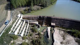
3_Top-view-of-Guma-hydropower-the-reservoir-and-the-fishway.jpg|Top view of Guma hydropower plant, the reservoir, and the fishway. | 3_Top-view-of-Guma-hydropower-the-reservoir-and-the-fishway.jpg|Top view of Guma hydropower plant, the reservoir, and the fishway. | ||
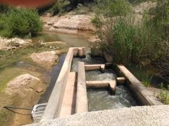
2_Top-view-of-Guma-fishway.jpg|Top view of the Guma fishway. | 2_Top-view-of-Guma-fishway.jpg|Top view of the Guma fishway. | ||
| Line 53: | Line 66: | ||
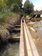
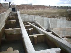
4_Vadocondes-fishway.jpg|The bottom part of the Vadocondes vertical slot fishway | 4_Vadocondes-fishway.jpg|The bottom part of the Vadocondes vertical slot fishway | ||
11_Upstream-part-of-fishway-in-Guma-dam.jpg|The pool and weir fishway at Guma | 11_Upstream-part-of-fishway-in-Guma-dam.jpg|The pool and weir fishway at Guma | ||
| − | </ | + | </gallery> |
Latest revision as of 12:04, 13 April 2020
| Fact box: Guma and Vadocondes | |
|---|---|
| Country | Spain |
| River | Duero |
| Operator | SAVASA |
| Capacity | Guma: 2.25 MW, Vadocondes: 1 MW |
| Head | Guma: 8.85 m, Vadocondes: 3.75 m |
| Inter-annual discharge | 17.6 m3/s |
| Turbine(s) | 2 Kaplan turbines at each HPP |
| Detailed report | Click for pdf |
Contents
Introduction
The Test Cases of Guma and Vadocondes are situated on the Duero river, which is located in the northwestern part of Spain. The source of the Duero river is in the Castilla y León region, which it crosses from East to West to then enter Portugal where it finishes its way into the Atlantic ocean. The total length of the river is about 900 km and the catchment area is 98,400 km2. The presence of hydropower plants (HPPs) in the Duero river is quite common, with 140 small hydropower plants (below 5 MW) and 23 large HPP situated on the Duero river.
The hydrology of the Duero river on this zone is characterized by low flows in summer (regulated flow for irrigation mostly derived through channels) and medium-high flows during winter and early spring, associated with rainy season and snow episodes. Upstream migration period for native cyprinids is from April to June, with mean monthly flow in the Guma-Vadocondes case of study reach, approximately between 15 and 30 m3/s.
About the hydropower plants
Boths, Guma and Vadocondes, are run-of river hydropower plants with an installed capacity of 2.25 MW (Guma) and 1 MW (Vadocondes), respectively. Each has 2 Kaplan turbines installed. The mean annual discharge is 17.6 m3/s, varying between 6 and 48.9 m3/s, respectively the minimum and the maximum mean annual discharges.
Layout
The Case Study site and relevant water body of the Duero reaches from 28 km upstream of the Guma HPP to 16 km downstream of the Vadocondes HPP. The two HPPs are placed in Guma and Vadocondes villages (Duero River, Burgos province, Central-North of Spain). The distance between both HPPs is about 3.9 km –the Guma dam is close to the end of the Vadocondes reservoir– and they are operated coordinately by the same company (SAVASA). Vadocondes reservoir has a length of about 2 km and Guma reservoir is 3 km long, with a maximum depth in Guma of about 8 m and in Vadocondes of 2.5 m. Guma is euipped with a pool and weir fishway and Vadocondes with a vertical slot fishway.
The Operator: SAVASA
SAVASA (Salto de Vadocondes S.A.) is a small hydropower company which operates the HPPs of Guma and Vadocondes. It has always shown interest for fish conservation, being a regional pioneer in implementing devices for river connectivity and in improving the knowledge about fish behaviour (e.g. building a flume for fish swimming research in its installations).
Pressures on the water body's ecosystem
Several dams with different purposes upstream and downstream of the two HPPs pose a problem for the continuity of the water body and thereby for fish migration. The native fish species are in decline and several alien species are appearing and/or increasing in number. The flow is highly regulated for irrigation and hydropower uses and there are a lot of artificial lentic habitats due to the presence of dams, which have an effect on the hydrologic regime. There are heavy agricultural uses in the area, with a significant use of agrotoxins, which leak into the water. Several dams block the sediment transport, with no law, so far, to enforce an improvement of the situation.
Test case topics
Fish population
The river is dominated by small and medium size reophilic native cyprinids like Iberian barbel (Luciobarbus bocagei), northern straight-mouth nase (Pseudochondrostoma duriense), Northern Iberian chub (Squalius carolitertii) and Pyrenean gudgeon (Gobio lozanoi). All of them are suffering a decrease in their populations (specially nase, wich is an endemic species) and allien species are increasing their presence (mainly Alburnus alburnus).
Upstream migration
The main facilities for upstream migration are the fishways built on each dam (all native species are potamodromous). At Guma, it is a pool and weir fishway, with submerged notch with bottom orifice. It has a slope of 8.77 % and covers a trial height of 8.85 m. Vadocondes has a vertical slot fish pass with a trial height of 3.75 m. Both have supplementary attraction flow into the fishway entrance.
E-flow
Due to the hydropower plant type (over the dam and run-of-river type), there is no legal requirement for ecological flow. Nonetheless, fishways always must have enough flow for operating and therefore the downstream by-pass of the river always maintains a minimum flow of 0.25-0.50 m3/s.
Research objectives and tasks
This hydropower plant type (run of river) is quite common on the main Spanish river basins. The work at the Test Case sites aims at improving the knowledge on the impacts this type of HPP has on fish migration and location of ascent paths. Different flow configurations through the turbines and fishway-attraction flow will be tested to maximize the relationship between fish upstream movement and hydropower production. Also, fish passage through turbines and their survival using different turbine configurations will be an important result about HPP management and impact.
Research tasks
The research tasks and field studies conducted at Guma and Vadocondes are:
- Population and habitat analysis
- Analysis of the conceptual solutions and facilities for fish migration
- Assessment and improvement of fish mortality in the turbines
- Spawning areas and hydro-morphology to attain self-sustainable populations
- Migration facilities and attraction flow
- Hydraulic modelling of attraction flow
Results
Results show that the most abundant native species in the river reach affected by the HPPs are Luciobarbus bocagei and Gobio lozanoi. A few years ago, Pseudochondrostoma duriense was also present in the reach, but it has suffered an important decline in recent years (information obtained from collected data and observations from river authorities, fishermen and people from nearby villages). Current fish assemblage is mainly characterized by the presence of invasive and alien species, probably due to the dominance of lentic sections. Alburnus alburnus, an invasive fish species in the Iberian Peninsula, is the most abundant, even relatively to native ones. In addition, alien crayfishes (Procambarus clarkii and Pacifastacus lenisculus) keep an important presence in the river reach.
The potential spawning grounds for native cyprinids are scarce in the studied reach (six in total), representing less than 2% of the riverbed area. The low availability of spawning grounds seems to be influenced by the floodable areas of both HPP reservoirs. Moreover, the spawning areas show excessive silting.
Regarding Guma and Vadocondes fishways efficiency, 52% (211/411) and 31% (27/87) of the tagged fish (L. bocagei and P. duriense), respectively, were detected during their upstream movement. The ascent success for Guma was 61% (129/211) and 70% (19/27) for Vadocondes. Median ascent time was less than 4 h, with a median time per meter of ascended height of 26 min/m in Guma and 6 min/m in Vadocondes. These values seem to indicate that both structures do not cause an important migration delay for the tagged fish species. Recorded fish movements were related to water temperature and peak flows (Figures 1, 2 and 3).
In addition, the collected data reveals that Guma fishway can be a downstream migration route, as well. Regarding the fish that were released upstream Guma dam, 42% (144/343) were found in the fishway and 64% (92/144) of these fish completed the descent.
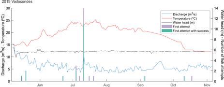
Figure 1: Fish attempts to pass and ascent success in Vadocondes fishway, related to flow discharge and water temperature. Water head refers to the difference between water levels upstream and downstream of the fishway.
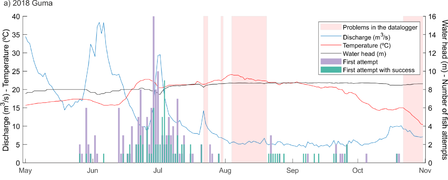
Figure 2: Fish attempts to pass and ascent success in Guma fishway (2018), related to flow discharge and water temperature. Water head refers to the difference between water level upstream and downstream of the fishway. Between 30/10/2018 and 01/04/2019 data logger was running but there were no data in the antennas.
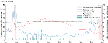
Figure 3: Fish attempts to pass and ascent success in Guma fishway (2019), related to flow discharge and water temperature. Water head refers to the difference between water level upstream and downstream of the fishway. Between 30/10/2018 and 01/04/2019 data logger was running but there were no data in the antennas.


Gallery
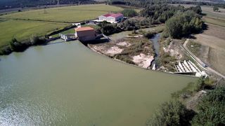
Top view of Guma hydropower plant, the reservoir, and the fishway.
Top view of the Guma fishway.
Bottom part of the Vadocondes fishway.
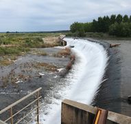
Guma dam spillway in spring.
The bottom part of the Vadocondes vertical slot fishway
The pool and weir fishway at Guma


