Altusried test case
| Fact box: Altusried | |
|---|---|
| Country | Germany |
| River | Iller |
| Operator | LEW |
| Capacity | 4 MW |
| Head | 9 m |
| Inter-annual discharge | 46.5 m3/s |
| Turbine(s) | 2 Kaplan turbines |
| Detailed report | Click for pdf |
Contents
Introduction
The river Iller is located in the far south-western part of Germany. It flows into the river Danube near the city Ulm. The river Iller originates from the confluence of the three rivers Stillach, Breitach and Trettach near the city Oberstdorf in the “Allgäuer Alps”, south Germany.
It’s catchment area has a size of 2152 km2. The HPP Altusried is the first HPP of a power plant chain of five HPPs that are operated by the LEW Wasserkraft GmbH. The last HPP of the LEW Wasserkraft GmbH is near Lautrach. In the downstream area of the LEW Wasserkraft GmbH HPP chain there are an additional 8 HPPs.
The hydrology of the Iller is characterized by sustained flows in winter, high water levels in spring due to snow melting and low water periods from August to October. At Altusried, the main Test Case HPP at the Iller, the mean interannual discharge is 46.6 m3/s (level Kempten).
About the hydropower plants
The HPP at Altusried is a run-of-river HPP with an installed capacity of 4 MW and a mean annual output of 30 million kWh. The HPP has two Kaplan turbines, each with a flow rate of 50 m3/s and a drop height of 9 m. The hydropeaking operation mode has been minimized since 2014.
Layout
There is a big reservoir in the upstream area of the Hydropower plant. In the downstream area of the HPP the river Iller is still flowing. After a free flowing area of around 1500m impoundment by the next reservoir starts. The LEW Wasserkraft GmbH has built a fish bypass channel around the HPP in 2015. It is 700 m long and has a mean flow of 1 m3/s.
The Operator: LEW Wasserkraft GmbH (LEW)
The LEW Wasserkraft GmbH is a 100 % subsidiary of the Lechwerke AG. It runs and maintains 36 HPPs at the rivers Danube, Günz, Lech and Iller and is thereby one of the leading HPP operators in Bavaria, Germany. The company produces over 1 billion kWh energy out of regenerative hydropower per year. [Read more.]
Pressures on the water body's ecosystem
The main pressures on the water body are morphology and hydrology. The formerly high pressure for river continuity, has been reduced through a fish bypass channel which has been built in 2014 - 2015.
The pressures are mainly caused by morphological issues which are results of the HPP. There is a lack of important habitats such as juvenile habitats, spawning habitats and the reophilic interstitial. The LEW Wasserkraft GmbH is working on this challenges with two restauration programmes, the Illerstrategie 2020 and the EU-found program ISOBEL.
Test case topics
Fish population
The river is dominated by reophilic and potamodroumous species. The main species are greyling, barbel, nase, brown trout, danube salmon, chub and several small fish species. In the reservoir basins, typical lake fish species such as tench, rudd, carp and pike can also be found. Since 2016 the LEW together with the University of Augsburg are investigating what types and numbers of fish using the fish passes constructed by LEW on the 5 hydropower plants of (from downstream to upstream) Lautrach, Maria Steinbach, Legau, Fluhmühle and Altusried. Every fish swimming through a fish pass is caught in a catch construction upstream in the fish pass. The catch construction (called counting pool) is evaluated nearly daily and fish that are caught are measured (length) and marked. The mark is a blue dot on their belly near the left or right pectoral, pelvic or caudal fin, depending on the fish ladder they were passing. In this way, migratory route of marked fish can be evaluated.
Migration devices
A fish bypass channel has been built 2014 - 2015. It has a length of 700 m and a flow of 1 m3/s. To also fulfill a compensation habitat function, juvenile and spawning habitats have been built into the fish-bypass channel.
Downstream migration
Downstream migration is possible during weir overflow or while the bottom outlets are opened. Thrash racks in front of the turbines, with a spacing of 20 mm between the racks, prevent fish from swimming into the turbines.
Upstream migration
The upstream migration is possible through the fish bypass channel. Within a monitoring programm, over 7000 fish have been documented using the fish bypass channel for upstream migration within 3 years.
E-flow
The minimum outflow of the turbines is 9.0 m3/s, during the whole year. This regulation is part of the “Illerstrategie 2020” of the LEW Wasserkraft GmbH. It is based on the natural minimum flow of the river Iller.
Research objectives and tasks
At the Test Case Altusried, the ways fish are finding the downstream entry of fish bypass channels is being studies. For this, fish tagging and acoustic telemetry is used to follow the ways of fish into the bypass channel. Additionally, Flow measurements are conducted in the outflow area of the fish ladder. This information is used to develop an agent-based fish movement model incorporated in the fish habitat simulation model CASiMiR. The research work is implemented by LEW, SJE, INBO, and TUT.
Research tasks
The research tasks and field studies conducted at the HPP on the river Iller are:
- Telemetry studies
- Velocity fluctuation measurements using the Lateral Line Probe
- 2D hydrodynamic model and CASiMiR migration model
- Population and habitat analysis
Results
Population and habitat analysis
The impact of the newly created fish-bypass channels and habitat measures have been monitored with electro fishing campaigns from 2016 – 2019 that are carried out twice a year on a length of 1500m downstream at both shorelines against the flow and in the middle of the river with the flow. The results of the electro fishing campaigns indicate the presence of all characteristic fish species in the Iller and thus an improvement of the formerly poor fish community status. Especially barbel, Danube salmon, grayling, chub and brown trout were caught in gratifying numbers, both in juvenile and adult stages. In spring 2018 even 6 young Danube Salmon were found. Only the population of nase is still in a rather poor condition.
Acoustic 2D telemetry fish tracking
The Vemco Positioning System (VPS) was applied to track fish swimming behaviour in 2D. Through the fish telemetry study, 15 million fish positions of 47 wild fish, 25 grayling and 22 barbel were collected. The tagged fish stayed in the VPS network between 2 and 92 days, whereby barbel resided on average for longer in the area than grayling. The fish detections of the hydrophones in the fish pass already indicate that 12 tagged grayling and 8 tagged barbel found the entrance of the fish ladder at least once and swum up at least half way. Of these, 10 grayling and 6 barbel then also found their way upstream into the counting pool.
Hydrodynamic modelling
A hydrodynamic model was set up using Hydro-As_2D to derive flow velocities and water depth as input parameter for the developed migration model. To cover the wide flow range that can occur during migration periods, the flow scenarios considered in the model range from 10 m3/s to 80 m3/s. The results from the hydrodynamic model show that for a low flow situation with 10 m3/s the flow velocities are increased close to the area of the fish ladder outlet. Usually this zone of increased flow velocities is considered to have a guiding function for fish searching the fish ladder entrance. But even for the low flow situation the increased flow velocities can only be detected in the direct vicinity of the fish ladder entrance. For higher flows the extension of the higher flow velocity area is much less distinct.
Migration model
An extension of the habitat simulation system CASiMiR is being developed with input from the Test Cases. This new CASiMiR-Migration model is designed to simulate the migration behaviour of fish. For Altusried, the model has been applied to a lower flow velocity threshold of 0.15 m/s and an upper threshold of 1.5 m/s. When positioning the virtual fish equally over the river width in the lower part of the river stretch 10% of fish find the fish ladder entrance with flow velocities of 10 m3/s, 7% with 20 m3/s and 5 % with 60 m3/s in the river. I.e. the higher the flow in river the less distinct is the attraction flow when considering only flow magnitude and direction. By a first evaluation of the fish tracks it is already clear that the percentage of fish finding the fish ladder entrance is much higher than these values. This indicates that the current model has to consider additional parameters as mentioned before.
Gallery
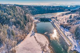
Areal view of the hydropower plant Altusried (picture rights: iCFlussbau, Villach Austria)
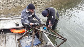
Installation of acoustic receivers in the Iller (picture rights: Ine Pauwels, INBO
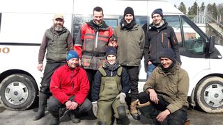
The team conducting the fieldwork at Altusried (picture rights: Ine Pauwels, INBO)
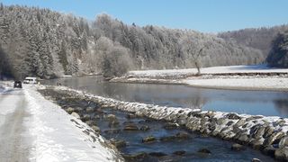
View of the Iller downstream of the HPP with the fishpass (picture rights: Ine Pauwels, INBO)
flussbauiC_VillachAustria3.jpg)
_in_the_Iller_(c)Ine_Pauwels,_INBO.jpg)
_Ine_Pauwels_INBO.jpg)
_Ine_Pauwels_INBO.jpg)