Freudenau test case
| Fact box: Freudenau | |
|---|---|
| Country | Austria |
| River | Danube |
| Operator | VERBUND |
| Capacity | 172 MW |
| Head | 8.6 m |
| Inter-annual discharge | 3000 m3/s |
| Turbine(s) | 6 Kaplan bulb turbines |
| Detailed report | Click for pdf |
Contents
Introduction
The Danube River is the second largest river in Europe with a total length of 2,850 km and a total catchment area of 817,000 km². The project area is located on the upper reach of the Danube River (distance from the mouth: 1,921 km, catchment area: 100,700 km²) within the city of Vienna/Republic of Austria. The inter-annual discharge varies between 900 to 5000 m³/s.
The Danube water body upstream of the Test Case is classified as having a moderate to worse ecological potential, while the waterbody downstream is classified as a natural water body with good ecological status.
About the hydropower plant
The hydropower plant at Freudenau is a run-of river hydropower plant. It has an installed capacity of 172 MW and a mean annual output of 1,052 GWh.
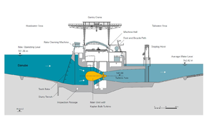
Layout
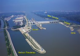
The Hydropower Plant at Freudenau is a multi-purpose hydro-power scheme located in the southern region of the Vienna metropolitan area. Six Kaplan bulb turbines are installed in the power house which is located in the middle of the river between the lock and weir systems. With a runner diameter of 7.5 m the turbines rank among the biggest in Europe. Ecological measures include the water supply to the New and Old Danube, new biotopes, and an ecologically designed bypass stream as a fishway on the Danube island.
The Operator: VERBUND
VERBUND is Austria’s leading electricity company and one of the largest producers of electricity from hydropower in Europe. The group generates around 95 % of its electricity from renewable energy, primarily from hydropower. VERBUND power plants cover 40% of the annual Austrian electricity requirement of approx. 70,000 million kWh. VERBUND was founded in 1947 and has been listed on the Vienna Stock Exchange since 1988; 51 % of the company’s shares are owned by the Republic of Austria.
In the area of the research & development of new applications for electricity, VERBUND is among the pioneers and innovation leaders and also rich in experience in successful implementation of LIFE Nature projects (e.g. LIFE+ Traisen, LIFE+ Netzwerk Donau).
Pressures on the water body's ecosystem
The Upstream water body (409040013) is a heavily modified water body with the following main pressures: hydropower, navigation and flood control.
All pressures are directly anthropogenic and highly connected to the need to save life and goods as well as economical use. The ecological potential based on the WFD is “moderate or worse”. The reasons for designation as HMWB ((heavily modified waterbody) are manifold and any measures to reach the good ecological status have significant adverse effects on hydropower, navigation, & flood control.
The Downstream water body (409040008) is a natural water body with the main pressures: navigation and flood control. The ecological status is defined as “good”.
Test case topics
Fish population
The river is dominated by potamodroumous species. Recent investigations (2010) of the fish fauna below the HPP (r-km 1880 - 1894) showed a good fish-ecological status according to WFD compliant assessment. A total of 31 species of the Leitbild and seven species not included in the Leitbild were found. The fish biomass was about 184 kg /ha and was dominated by pike, bream, pike prech, catfish, and Giebel. The abundance was about 7.500 Individuals per hectare and was dominated by bitterling, perch, roach, and rudd.
Downstream migration
Downstream migration is possible through the turbines (one of the largest turbines in Europe with a diameter of 7.5m), through the navigation locks, and through the nature-like fishway.
Upstream migration
During the course of construction of Freudenau power plant (commissioned in 1999), a fish pass was erected on the orographic left bank between the Danube and the flood discharge channel of the New Danube. This comprises an approx. 1 km long bypass stream and an upstream connecting pool pass. In the process, the bypass stream negotiates an average difference in height of 6.7 m and the pool pass that of 2 m. The entrance to the bypass stream is situated approx. 500 m downstream from the power plant‘s weir system. Two estuaries with a permanent flow of water ensure the attracting currents for detection of the fish passes. In the event of increased mean flows, a third branch forms as an additional residual flow.
Apart from the stable bank at the island between the Danube and the right estuary, as well as in the lowest section of the left estuary, the banks are unfortified. As a result, currents can lead to small-scale redistribution and continue to develop dynamically. In addition, parts of trees and rootstocks have been installed, which - as deadwood - represent important structures for fish habitats. The 19 pools of the pool passes comprise a total length of 420 m.
The average difference in water level between the individual pools amounts to 11 cm. The rough, asymmetric shape of the sills made from rough blocks increases the flow diversity and therewith the connectivity. The pools are characterized by flow rates of less than 1 m/s and scours of up to 1.5 m deep. As a result of the very slow flow velocity, fine sediment is increasingly covering the original sand-gravel mixture as integrated bottom substrate. The residual flow of the pool pass amounts to 900 l/s. The pool pass can receive additional residual water by means of an electronically controlled spillway gate or via an emergency pump. The bypass stream is fed via the outflow from the pool stream and via two flood gates depending upon the season and water flowing from the Danube. The rewith with dynamic total residual flow fluctuates between 1,500 l/s and 3,600 l/s.
Sediment management
Gravel is artificially added downstream of the HPP (bed-load addition) to prevent further erosion. Without gravel feeding this erosion would be about 8-10 cm per year. The amount of added gravel is about 235.000 m³ per year to prevent this erosion.
Research objectives and tasks
The main interest for future planning of fishways in large rivers as the Danube is the positioning of the fishway entrance and the assumed “Sackgasseneffekt” (cul-de-sac-effect) during the upstream migration of fish. The Test Case Freudenau, situated on a large river, gives the opportunity to study this question. Orientation of potamodromous fish and implications for the positioning of the fishway entrance will be investigated using the method of numerical modelling of coupled hydro-thermo-chemical-mechanical cues. These results will be combined with the results and interpretations of fish swimming paths, obtained with 2D Telemetry. The field studies are subcontracted by VERBUND and the numerical computations are carried by TUM.
Research tasks
The research tasks and field studies conducted at Freudenau are:
- 2D and 3D modelling of attraction flow at fishway
- Telemetry study of fish swimming paths
- Coupled hydro-thermo-chemical-mechanical modelling
Results
Feasibility study
Because the study area is characterized by fast flow conditions and increased sound reflection due to riprap and shallow areas around the fish pass entry, a feasibility study to test the possibilities of a successful telemetry study in such a large river as the Danube was carried out in 2019. The study resulted in low tag detections in the vicinity of the hydropower plant but satisfying results downstream the entrance to the fish pass. While it is not possible to locate fish directly downstream of the turbines or to cover the whole width of the river due to heavy ship traffic, several hydrophone arrays were positively tested close to the influx building Langenzersdorf. Satisfying positioning results could be obtained using six hydrophones and test tags. This results in a limitation of the actual telemetry study to the fish pass and an area of 500 – 800m downstream of its entrance.
2D Telemetry study
To investigate the migration routes adult nase take during spawning season when trying to find the fish pass entry, a 2D telemetry study was conducted in April 2020. Hydroacoustic telemetry array was established in the Danube downstream the entrance to the fish pass. Additionally, radio tracking was used to observe tagged adult nase beyond the boundaries of the hydroacoustic surveillance. During the main study period the discharge varied between 1,200 m³/s and 1,700 m³/s. The turbined water is directed to the left side of the river channel and creates a strong current right in front of the entry to the fish pass. The morphology in the area is very heterogenous with water depths varying from 2 m to 10 m (Figure 1).
13 hydrophones of the type WHS3250 (provider LOTEK) were strategically placed in the study area to cover the left half of the riverbed approximately 100 m upstream and 500 m downstream of the entry to the fish pass.For the study, 35 male nase, previously caught in the lower section of fish pass of the HPP Freudenau, were tagged and released approximately 1 km downstream of the hydrophone array.
Fish positions were recorded during the period of April 15th to May 7th 2020, resulting in 13 fish swimming path with 3000 - 17500 location points each after data aggregation.
Numerical model
In order to analyses potential cues for orientation, a numerical model of the fish pass entrance and downstream area of the HPP has been set up using FLOW3D. The applied numerical model solves the hydrodynamic (Fig.2), temperature (Fig. 3) and chemical spatial (Fig. 4) distribution for two scenarios that reflect the conditions of the field measurement campaign.
As result the spatial pressure, velocity, temperature and tracer fields are available. The numerical result were be combined with the fish swimming path obtained from the telemetry study. Since the telemetry study was carried out during relative low flow conditions the discharge through the HPP varies between 1050 and 1400 m³/s. Additionally one has to point out that for these discharges the distribution of the discharge within the HPP varies and influences the tailwater characteristic visibly.
The temperature field within the numerical model is only influenced by the water temperature of the fish pass. Even the fish pass is fed with Danube water the interaction with the groundwater is much higher und therefore influences the water temperature in there. Records of BOKU, which were taken together with the telemetry study, show a temperature difference between Danube and fish pass of about +- 0.6 °C, varying over the day. During night the fish pass was colder compared to the Danube, while the ratio changed during the day. These dynamics in temperature is not considered by the numerical simulation. But, the numerical results show how far the temperature influence extends.
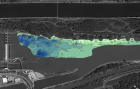
Fig. 1 Contour map of study area downstream of the HPP Freudenau (Picture rights: BOKU, image source: Google Earth).
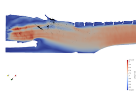
Fig. 2 Velocity field of tailwater of HPP Freudenau with a fish track (black points). (Picture rights: T. Liepert, TUM).

Fig. 3 Temperature field of tailwater of HPP Freudenau with a fish track (black points). (Picture rights: T. Liepert, TUM)
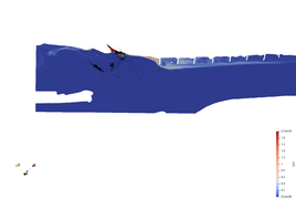
Fig. 4 Chemical (tracer) field of tailwater of HPP Freudenau with a fish track (black points). (Picture rights: T. Liepert, TUM)


Gallery
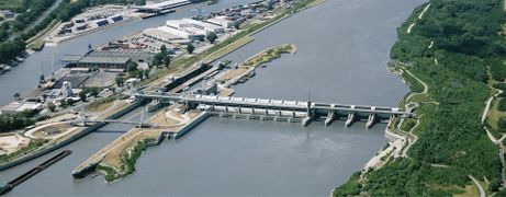
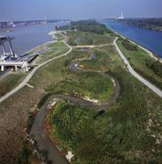
Aerial view of Fredenau hydropower plant (source:Verbund).
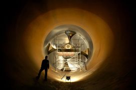
Kaplan turbine at hydropower plant Freudenau (source: Verbund).
Nature-like fishway at Freudenau (source: Verbund).
Layout of the hydropower plant Freudenau (source: Verbund).
Longitudinal section of the hydropower plant Freudenau (source: Verbund).
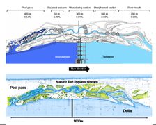
Layout of the nature-like fishway at Freudenau HPP and its different sections (source: Verbund).
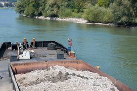
Sediment is being added downstream of the hydropower plant Freudenau (source: Verbund).


